Estimation of Fractional Plant Lifeform Cover for the conterminous United States using Landsat imagery and Airborne Lidar
Principle Investigator: Adriana Parra and Jonathan Greenberg
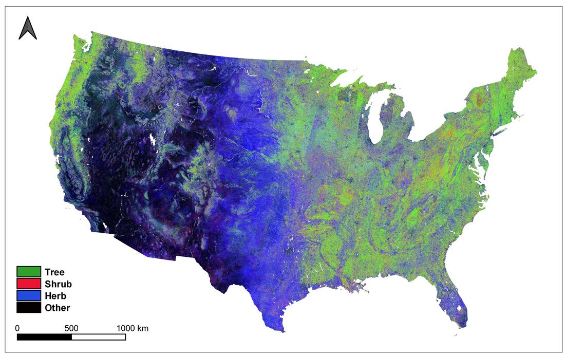
Overview: We produced annual 30 m resolution maps of percent lifeform cover (Tree, Shrub, Herb, and Other) and their uncertainties for the conterminous United States for the period of 1984 to 2018 using a quantile regression forest model calibrated from a combined airborne LiDAR / multispectral data and Landsat imagery database. The resulting predictions were compared to available fractional cover products with the same temporal and spatial resolution, and to different types of documented land cover change to determine the relative accuracy of the percent cover predictions. Our analyses showed a good agreement between estimated percent cover values and observed lifeform cover change processes. We found our approach yielded a higher accuracy of the Shrub, Herb, and Other cover estimates than existing fractional cover products, and had a similar performance of the resulting Tree cover estimate as compared to other available products. Our results indicate that the use of spatially dense training and validation data from airborne multisensor acquisitions facilitates the incorporation of a large range of variability in the response and predictor variables into model construction. The produced percent lifeform cover maps represent a consistent dataset of medium spatial resolution and long temporal record that does not rely on the use of ancillary data (e.g. topography and climate), and thus can be a valuable input in a variety of applications such as the analysis of land cover change processes, as well as ecosystem conservation and management.
Overview: We produced annual 30 m resolution maps of percent lifeform cover (Tree, Shrub, Herb, and Other) and their uncertainties for the conterminous United States for the period of 1984 to 2018 using a quantile regression forest model calibrated from a combined airborne LiDAR / multispectral data and Landsat imagery database. The resulting predictions were compared to available fractional cover products with the same temporal and spatial resolution, and to different types of documented land cover change to determine the relative accuracy of the percent cover predictions. Our analyses showed a good agreement between estimated percent cover values and observed lifeform cover change processes. We found our approach yielded a higher accuracy of the Shrub, Herb, and Other cover estimates than existing fractional cover products, and had a similar performance of the resulting Tree cover estimate as compared to other available products. Our results indicate that the use of spatially dense training and validation data from airborne multisensor acquisitions facilitates the incorporation of a large range of variability in the response and predictor variables into model construction. The produced percent lifeform cover maps represent a consistent dataset of medium spatial resolution and long temporal record that does not rely on the use of ancillary data (e.g. topography and climate), and thus can be a valuable input in a variety of applications such as the analysis of land cover change processes, as well as ecosystem conservation and management.
References:
- Parra, A. and J.A. Greenberg. 2020. Estimation of Fractional Plant Lifeform Cover for the conterminous United States using Landsat imagery and airborne Lidar. Remote Sensing of Environment. Submitted.
- Parra, A.S., Q. Xu, T. Dilts, P. Weisberg, J.A. Greenberg. 2017. Estimation of Fractional Plant Lifeform Cover Using Landsat and Airborne LiDAR/hyperspectral Data. American Geophysical Union Fall Meeting, San Francisco, CA.
- Greenberg, J.A., Q. Xu, B.D. Morrison, A. Man, M.M. Frederickson, C. Ramirez, B. Li. 2016. Towards a portable, scalable, open source model of tree cover derived from Landsat spectra. American Geophysical Union Fall Meeting, San Francisco, CA.
- Greenberg, J.A., Q. Xu, Z. Xu, B. Li, J. Balamuta, C. Reents, B. Morrison, C. Ramirez, and K. Evans. 2015. LiDAR as calibration and validation data of a Landsat-derived tree cover map. Annual Meeting of the Association of American Geographers, Chicago IL.
Funding Sources:
- Laspau Fulbright
